Day 1 - Ochagavia to Izaba
Days 1 to 7 - Ochagavia to Arrens-Marsous
Do be sure to make full use of the place markers and different map modes on the map above while reading the story!
Early start, 6am crossing the Rio Anduña in Ochagavia.
The previous day was pretty sweltering, so I decided a super early start to beat the heat was in order. After sleeping through a massive thunderstorm I brewed up, eat some porridge and headed off on the first proper day of my walk. Pretty much the whole day was on pista (the techical term for a rough farm style track). This wound up through wooded hillsides with an occasional view to, erm, some other similiar looking wooded hillsides. All in all pretty pleasant. The landscape is quite similiar to some parts of the UK, rolling hills and woods, the main difference being it's hot and the cows & sheep have bells rounf their necks. After a while I reached the Merendero de Zotrapea which I was excited about because it sounds pretty grand but it turns out to be a pile of logs, a picnic table and a signpost. Anyway I stopped here for a break before carrying on.
road to Isaba/classic pista exemplar
AFter the Merendero the path leads upwards into more open terrain, with gorse, small limestone outcrops and short cropped grass from the millions of sheep in the area. Walking along a small ridge brings one to a shady spot with a nice view. Due to my early start, and the ease at which one can cover many miles when walking on Pista, I released that at was only 11am or so and I'd nearly finished the stage. I decided to have a break in the shade and dry my tent which was still wet from the previous nights storm:
pretty nice huh? looking back, the route roughly follows the ridge and tree line that runs left to right
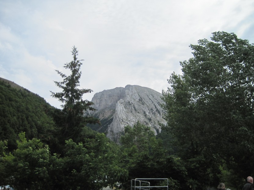
After this the way drops quite sharply through dense woodland towards the village of Isaba/Izaba, with tantalising glimpses of the mountains of future days:
This is the Peña Ezcaurri which will be covered in the next exciting installment
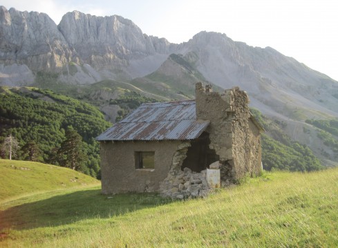
After a while getting lost in the woods I arrived, nearly in Isaba, at the Santuario de Nuestra Señora de Idoia. This is a lovely spot, a 16th century chapel, with a beautiful garden featuring a spring with delicious cold water. I stopped here for quite a long time, before heading into Isaba.
Chapel with Peña Ezcaurri in the background
blurry timer photo
Day 2- Izaba to a lonely mountainside
After a comfortable night in a hostel (there is no campsite in Isaba) I awoke bright and early for the next leg of the journey, including an ascent of the 2045m Peña Ezkaurre (http://elbrilloenlamirada.blogspot.co.uk/2015/06/subida-la-pena-ezkaurre-senderismo-por.html)
I was treated to amazing sun rays above the summit as I walked up steeply through gloomy pine forests
Looking back to Izaba from the edge of the pine forest
<- Out of the woods there were about 18734579843 million sheep running around
and here a massive VULTURE took off from near me ->
<- vulture alert
REAL LIFE VULTURE ->
A vulture soaring above a wooded Basque hillside
A panoramic view of the south face of the Pena Ezkaurre.
At this point I waited an hour for clouds to clear from the summit. This point also marks the border between Navarre and Aragon.
The route takes the west flank (left of picture), scrambling easily up limestone shelves until the summit is reached.
it was surprisingly cold up there
Here's me on the summit - I chatted to a Spanish couple up here, the first walkers I'd seen in 2 days. This is a quiet part of the GR11
Summit panorama from the Pena Ezkaurre. Note clouds in France, clear skies in Spain. This would become a common sight. Click here for the hi res version for max detail and mountain spotting. The Pic Midi d'Ossau can be seen from here.
From here I descended the N face of Ezkaurre (pictured left) which was steep and somewhat terrifying (although nothing compared to later descents). This led to the sharp pass of the Collau d'Abizondo. A steep path descended through a beech forest, which eventually ended up in the small hamlet of Zuriza. I stopped at the campsite and had a beer and a sandwich, intending to stay the night there, but I got a bad vibe about the place, and with 3 hours of good light left I decided to continue up into the mountains. Following the valley of the Barranco de Petraficha, underneith the rocky Alano ridge, I headed to the Refugio de Taxera, a shephards hut marked on the map. Upon arriving I discovered that it had partially collapsed and looked kind of dangerous, so on I went to another, higher hut. I met a shephard and his dog on the way, who said that the higher refuge would be locked, and that I would have to camp, which I did, after spending rather a long time locating a tent sized piece of flat ground.
Refugio de Taxera - "not in such condition now" says the guidebook - they weren't wrong. Shame really
The Alano Ridge from Zuriza
Superb camping spot overlooking the valley, with the Alano ridge above it
And here ends day 2 - roughly 23km, ~1200m ascent, 1 dog, 1241481204812 billion sheep and 2 vultures
Day 3 - 29th June 2011 - A lonely mountainside to rainy Candanchu
CLOUDY FRANCE
SUNNY SPAIN
Pic Midi d'Ossau below here